|
Kamchatka volcano warnings go offlineMarch 12, 2007Courtesy of Far North Science 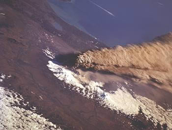
Klyuchevskoy Volcano erupts in Oct. 1994 Without alerts issued by the Kamchatkan Volcanic Eruption Response Team (KVERT), jetliners flying between North America and Asia could get little or no warning if any of the 29 active volcanoes on the Kamchatka Peninsula erupt and send ash clouds roiling into air traffic lanes, particularly during bad weather or other conditions where satellite coverage was unable to pinpoint the plume. The volcanoes produce ash that threatens air traffic lanes three or four times every year. "Planes are definitely at more risk now to encountering volcanic ash than if KVERT were issuing the notifications themselves, though you still need to have the volcano erupt ash to a high enough altitude and then have the winds be in the right direction to put planes at risk," said Thomas Murray, AVO scientist-in-charge, in an email message. "AVO and National Weather Service are closely watching satellite data for indications of eruptive activity, but satellite data alone is insufficient to always catch an eruption before an ash cloud becomes a hazard to planes." The two agencies are now trying to mitigate the increased risk by using reports from Russian volcanologists with images from U.S. satellites, Murray said. This week, for instance, AVO has issued information statements about drifting ash after Russian scientists let them know Chikurachki Volcano had blown over the weekend. 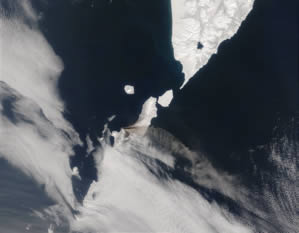
Chikurachki Volcano sends a plume of ash streaming
eastward over the North Pacific on April 24, 2003. "If the weather is clear (and it is often not) we likely would be able to see a significant ash cloud," Murray said in an email message, "though (the Russian team) would in most cases know of the eruption much more quickly than we would and get the notification out more quickly." Hundreds of jet flights cross the North Pacific between North America and Asia each week, carrying up to 20,000 passengers and millions of dollars in cargo every day. Along the way, they run a gauntlet of active Alaskan and Russian volcanoes, marking the northern rim of the Pacific Ring of Fire, one of the world's prime geologic hotspots. When sucked up by air intakes, the tiny abrasive ash particles of rock and glass produced by an eruption can destroy or damage jet engines and turbines, causing aircraft to plummet from the sky. In December, 1989, a KLM Boeing 747 with 231 passengers and 13 crew flew into a Redoubt Volcano ash cloud about 25,000 feet above Talkeetna, about 100 miles north of Anchorage. All four engines quit. The jumbo jet plunged for the next 12 minutes, dropping more than two miles, before the pilot managed to restart the engines. Minutes later it landed in Anchorage with no serious injuries among its terrified and shaken passengers, and $50 million in damage to its engines. At least 100 other aircraft have flown into ash clouds during the past 20 years across the world. No one has died, but equipment has sustained hundreds of millions of dollars in damage. To avoid such a catastrophe, the North Pacific volcanic chains have been monitored around the clock by American and Russian scientists since the early 1990s. Founded in 1988, AVO began watching the four active volcanoes in Cook Inlet and quickly expanded coverage down the Alaska Peninsula and Aleutian Chain. Now more than 20 volcanoes have been wired with seismic sensors and webcams, while the observatory's 22 full-time staffers conduct research and issue daily reports about volcanic action. The Kamchatkan Volcanic Eruption Response Team, or KVERT, started operations in 1993 in cooperation with the Alaska observatory. The Russian scientists used their local network of seismic stations and field observations, combined with American satellite images, to share updates of volcanic activity on the peninsula with the world.
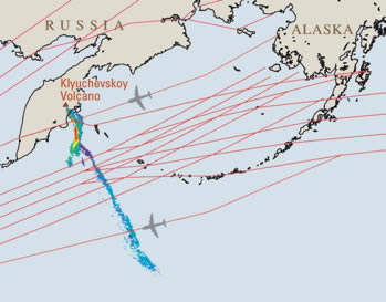
Ash cloud from Klyuchevskoy Volcano crosses
air traffic lanes on Oct. 1, 1994 In the first nine years of operation, the team issued 500 information releases and dozens of eruption alerts to airlines and emergency response agencies, according to a KVERT profile published online by the U.S. Geological Survey. Despite hundreds of thousands of flights during eruptive periods, no aircraft has reported damage from Kamchatkan volcanic ash, according to AVO. The most dramatic success came on Oct. 1, 1994, when Klyuchevskoy Volcano blasted ash 49,000 feet into the sky after three weeks of restless low-level earthquakes. The plume rode 150 mph winds more than 620 miles southeast and crossed into North Pacific air traffic lanes between 31,000 and 38,000 feet above the ocean. KVERT personnel issued an alert and, working with the AVO, within two hours, aviation authorities had rerouted flights to avoid the ash. If Klyuchevskoy Volcano exploded today with as much force and ash as its 1994 eruption, would a warning go out in time? This winter, Russian scientists notified AVO that the Federal Unitary Enterprise State Air Traffic Management Corporation of Russia stopped paying for KVERT operations on Jan. 1 and the team would no longer be able to issue alerts as of March 1. "We do not know official reasons for this action, which, unfortunately, has occurred before in KVERT's history," Murray said in a statement posted on the front page of the AVO website. "Attempts to negotiate renewal of the annual funding agreement by KVERT leadership have thus far failed. . This unfortunate event comes at a time when three volcanoes in Kamchatka are at Color Code Orange and intermittently producing ash." Murray said the FAA and the International Civil Aviation Organization have contacted Russian air traffic agencies about the situation. Although the Russian scientists are continuing to operate their seismic network and use web cameras on Kamchatka, Murray said, the AVO simply can't plug into their system and take over the job. Scientists can accurately interpret seismic data from a specific volcano only after detailed study. In Alaska, observatory scientists typically analyze data from a newly wired volcano for months before they feel confident enough to issue public updates on its status. The Alaska Volcano Observatory is a cooperative program of the U.S. Geological Survey, the UAF Geophysical Institute, and the AK Div of Geological and Geophysical Surveys. Check out AVO's award-winning web site: it's a virtual encyclopedia of Alaska volcanoes, with maps, history and photos. A volcano observatory also pulls together data from many sources - field measurements, pilot reports, ground observers, satellite images - and then evaluates it all based on previous experience with the volcano. That means alerts about Kamchatka Volcanoes should come from Kamchatkan scientists. "We do not have the long-term expertise needed to interpret the data from individual seismic stations nor the on-the-ground contacts that also provide information," Murray said. Most of Far North Science is written and edited by Doug O'Harra, a writer and journalist based in Anchorage, Alaska. |
|