
|
Next Big Quake: 'Locked and Loaded'March 22, 2007Courtesy of Far North Science 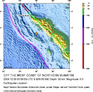
It struck along one of the world's great engines for producing large quakes - the subduction boundary between tectonic plates in the Indian Ocean. Yet scientists didn't realize at the time that this particular area off the west coast of Indonesia posed such a terrible hazard. "One lesson we should take away from the Sumatra-Andaman earthquake is that every subduction zone is potentially locked, loaded, and dangerous," wrote geophysicist Robert McCaffrey in "The Next Great Earthquake," published this week in the journal of Science. With an immense tectonic collision grinding away only 20 miles beneath the Alaska's southern rim, is there also a lesson for the Far North? Be ready, Alaskans. Be very ready. "We should not rule out completely another M9 (earthquake) in the not-so distant future," McCaffrey said in an email message. "We don't know the repeat time and the variability in that time." Alaskans ought to know earthquakes. The colossal collision between tectonic plates has shattered the state into a maze of over-riding cracks and strike-slipping faults. Who can forget that the second largest quake ever recorded struck Alaska in 1964 - the Magnitude 9.2 Good Friday event of Prince William Sound? Each week, another 150 to 200 quakes large and small get located by the Alaska Earthquake Information Center.
In the essay appearing on March 23, McCaffrey, a professor of earth and environmental sciences at Rensselaer Polytechnic Institute in Troy, N.Y., noted that seismologists still struggle to predict which subduction boundaries will rupture next. For reasons that have to do with heating in the Earth, the speed of convergence and the mechanics between the plates, scientists rated the Sumatra-Andaman boundary as less likely to burst than many other sites. But the "Earth gave us a stark reminder of the important difference between improbability and impossibility," McCaffrey wrote. "Our understanding of where and when the next great earthquake will happen is in its infancy at best. We have not had enough time to decipher M9 behavior." More from a release explaining the essay: On Dec. 26, 2004, the earth beneath the Indian Ocean buckled and ruptured, unleashing one of the largest earthquakes in recorded history. Shockwaves from the magnitude 9.2 (M9) quake created a wall of rushing water that devastated communities up to 1,000 miles away. M9 earthquakes typically occur at a specific type of tectonic boundary called a subduction zone, where one plate is gently slipping underneath another plate, which causes friction, cracking, and lifting of the plates. An M9 earthquake can be created by only 20 meters of slip between two converging plates - less then the length of an 18-wheeler truck - but its effects can be global in their impact. Slips of this length only occur every 200 to 1,000 years or more at a particular boundary, leaving no reliable historic records to track their frequency, McCaffrey notes. Complete records are only available going back 100 years. Scientists had widely accepted that the age and speed of the subducting plate is important in creating M9 earthquakes, based primarily on support from this 100-year historical record. So what does all this mean for Alaska? The state remains one of the world hotspots for earthquakes, with as much as one-third of all the earthquake energy of the entire globe rumbling through local bedrock. Translate this into hazard, and you find that Anchorage is five times more likely to have a major earthquake than San Francisco, and eight times more likely than Los Angeles. Alaska, in general, has five times more earthquakes than California. Here's why. Southern Alaska, with most of the state's population, rests atop of the head-on collision between two of the Earth's tectonic plates. For millions of years, a vast chunk of Pacific Ocean floor has been pressed deeper into the mantle beneath the North American plate. The seam lies 100 miles out in the Gulf of Alaska, a crevasse in the Earth's crust that deepens into the Aleutian trench. Alaska Earthquakes USGS - AEIC The movement between plates may be only inches per year, about as fast as fingernails grow. But the pressures involved are immense. The buckling of the North American plate raised the Alaska Range and Denali. And the heating of the Pacific plate about 60 miles down generates the magma for the volcanoes of Cook Inlet and the Aleutian arc. Whenever you get a lock-up between North American and Pacific plates, or between other crustal chunks in motion, pressure builds. Eventually, they break free. That sudden movement is an earthquake. The last really large quake to hit Alaska came on the Nov. 3, 2002: the Magnitude 7.9 Denali Earthquake. It was the Earth's powerful temblor of that year and the biggest slip-strike earthquake in North America in almost two centuries. 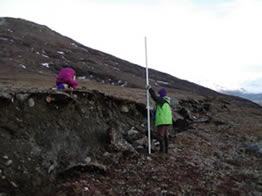
Geologists Patty Craw and Peter Haeussler But that quake, while causing more than $20 million in damage (and no serious injuries), was a baby compared to Alaska's Big One. At 5:36 p.m. on March 27, 1964, a jam between the Pacific plate and the North American plate released. A former section of the ocean floor half the size of California suddenly shifted 30 feet northwest, partially jolting deeper under Southcentral Alaska. 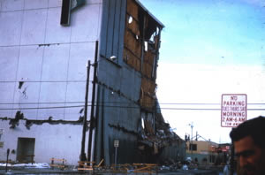
The J.C. Penney Department Store in Anchorage suffered damage from the 1964 earthquake. Credit: USGS The rupture started about 12 miles below sea level at the head of College Fjord in Prince William Sound, about 70 miles east of Anchorage. Over the next four minutes, the rupture expanded southwest over an area 500 miles long by 150 miles wide. As the movement began, the land west of Prince William Sound dropped several feet in elevation. The land to the east gained in elevation, with parts of Montague Island rising more than 30 feet. The shaking lasted seven minutes, liquefying clay and causing buildings to collapse in Anchorage. Tsunamis devastated Valdez, Chenega, Seward, Kodiak and Whittier. An estimated 132 people died, some as far away from the epicenter as California. The Good Friday quake remains the second most powerful earthquake recorded by modern science, slightly larger than the Sumatra-Andaman quake of 2004. Such quakes strike the subduction zone near Anchorage at intervals sometimes estimated at about 700 years by federal geologists. McCaffrey said he would put the odds of another M9 in any given year at one in 500. But, as he points out in his Science essay, averaging the time between the great earthquakes can be misleading. In Cascadia - the subduction zone centered on Seattle and the Pacific Northwest - the average interval might be calculated to be about 600 years. But the actual elapsed time between such devastating ground-ripping, tsunami-splashing wallops ranged from 200 to 1,500 years. Alaskans shouldn't be smug that the last M9 temblor came in 1964. "The 700 years (for Southcentral Alaska), if correct, would be an average over many, many thousands of years," McCaffrey said in an email. "The time between any two quakes could be much shorter than that. The shortest interval in Cascadia was about 200 years, so 50-ish for Alaska seems short but not a stretch. "How much do we want to bet on that being too short?" Most of Far North Science is written and edited by Doug O'Harra, a writer and journalist based in Anchorage, Alaska. |
|